
File:Concord Retreat.png
本预览的尺寸:800 × 342像素。 其他分辨率:320 × 137像素 | 640 × 273像素 | 1,024 × 437像素 | 1,280 × 546像素 | 3,235 × 1,381像素。
原始文件 (3,235 × 1,381像素,文件大小:780 KB,MIME类型:image/png)
摘要
| 描述 |
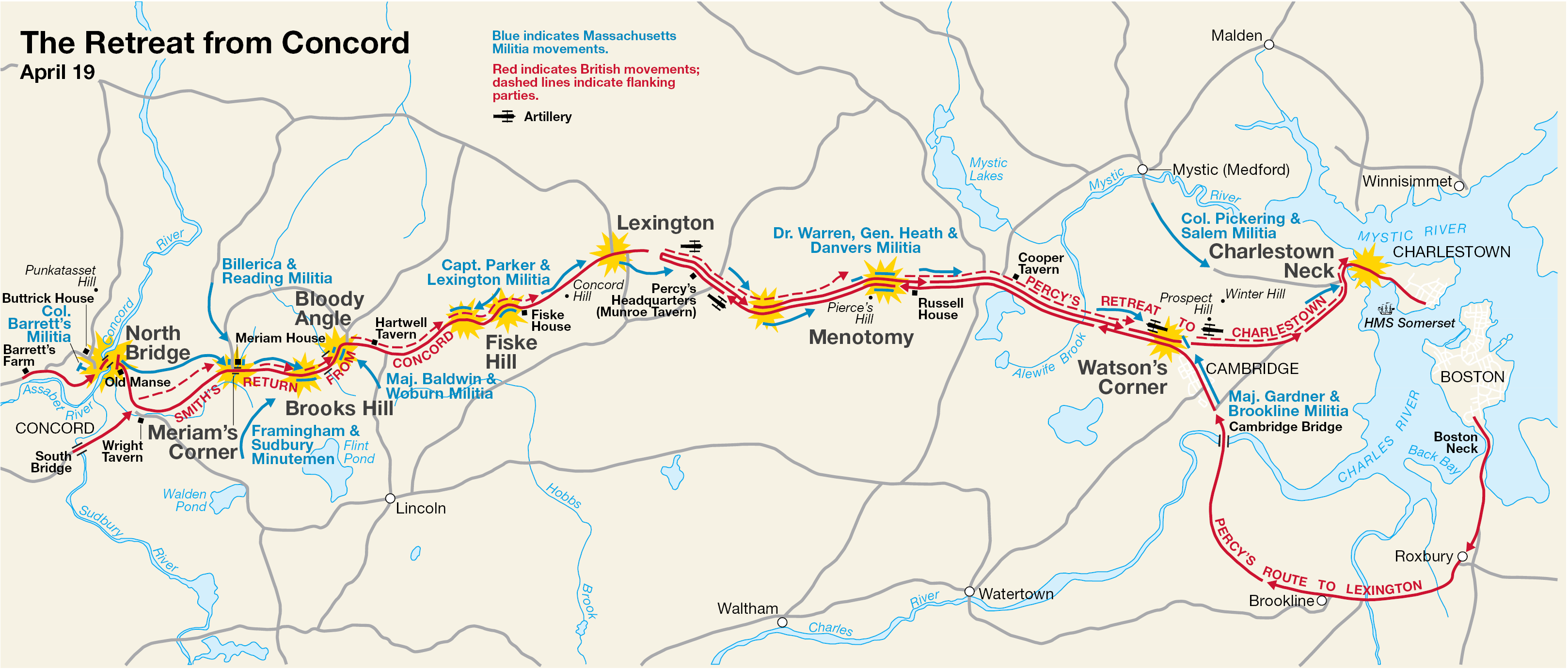
English: This is a map showing the route of the British army's 18-mile retreat from Concord to Charlestown in the Battles of Lexington and Concord on April 19, 1775. It shows the major points of conflict, as well as showing the route taken by Hugh, Earl Percy's reinforcements. |
| 日期 | 未知日期; source PDF created in 2000 |
| 来源 | http://data2.itc.nps.gov/parks/mima/ppMaps/MIMAmap2.pdf |
| 作者 | National Park Service |
| 其他版本 |
|

许可协议
| 该图片或媒体为美国国家公园管理局雇员在执行公务时创建。作为美国联邦政府的作品,此作品在美国境内属于公有领域。更多信息请参考美国国家公园管理局网站及美国国家公园管理局版权政策。 |
原始上传日志
本檔案是由Andrei Stroe使用CommonsHelper,從en.wikipedia轉移到維基共享資源。
原始描述頁面位於這裡。下列使用者名稱均來自en.wikipedia。
- 2006-11-30 17:35 Irayo 3235×1381× (799048 bytes) The Retreat from Concord April 19 (1775) Minute Man National Historical Park Battle Map http://data2.itc.nps.gov/parks/mima/ppMaps/MIMAmap2.pdf {{PD-USGov-Interior-NPS}}
文件历史
点击某个日期/时间查看对应时刻的文件。
| 日期/时间 | 缩略图 | 大小 | 用户 | 备注 | |
|---|---|---|---|---|---|
| 当前 | 2010年11月29日 (一) 19:11 | | 3,235 × 1,381(780 KB) | File Upload Bot (Magnus Manske) | {{BotMoveToCommons|en.wikipedia|year={{subst:CURRENTYEAR}}|month={{subst:CURRENTMONTHNAME}}|day={{subst:CURRENTDAY}}}} {{Information |Description={{en|This is a map showing the route of the British army's 18-mile retreat from [[:en:Concord, Massachusetts |
文件用途
以下3个页面使用本文件:
全域文件用途
以下其他wiki使用此文件:
- ar.wikipedia.org上的用途
- azb.wikipedia.org上的用途
- cs.wikipedia.org上的用途
- en.wikipedia.org上的用途
- es.wikipedia.org上的用途
- fr.wikipedia.org上的用途
- it.wikipedia.org上的用途
- ro.wikipedia.org上的用途
- ru.wikipedia.org上的用途
- th.wikipedia.org上的用途