
File:King 1950-10-18 weather map.jpg

本预览的尺寸:800 × 569像素。 其他分辨率:320 × 228像素 | 640 × 455像素 | 1,024 × 729像素 | 1,130 × 804像素。
原始文件 (1,130 × 804像素,文件大小:789 KB,MIME类型:image/jpeg)
摘要
| 描述 | ||||
| 日期 | ||||
| 来源 | NOAA Central Library Data Imaging Project | |||
| 作者 | NOAA Central Library, Silver Spring, Maryland | |||
| 授权 (二次使用本文件) |
|
文件历史
点击某个日期/时间查看对应时刻的文件。
| 日期/时间 | 缩略图 | 大小 | 用户 | 备注 | |
|---|---|---|---|---|---|
| 当前 | 2010年6月21日 (一) 14:30 | | 1,130 × 804(789 KB) | Vyznev Xnebara | convert from BMP to JPEG format (with quality 100) |
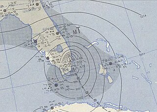
| 2009年9月21日 (一) 00:22 |  | 1,130 × 804(2.6 MB) | Iune | {{Information |Description={{en|1=Hurricane King of 1950 near landfall near Miami, Florida.}} |Source=http://docs.lib.noaa.gov/rescue/dwm/data_rescue_daily_weather_maps.html |Author=NOAA |Date=1950 |Permission= |other_versions= }} [[Category:1950 Atlant |
文件用途
全域文件用途
以下其他wiki使用此文件:
- de.wikipedia.org上的用途
- en.wikipedia.org上的用途
- es.wikipedia.org上的用途
- min.wikipedia.org上的用途
- pt.wikipedia.org上的用途
- www.wikidata.org上的用途