
File:Qing China 1820.png
本预览的尺寸:800 × 593像素。 其他分辨率:320 × 237像素 | 640 × 475像素 | 910 × 675像素。
原始文件 (910 × 675像素,文件大小:327 KB,MIME类型:image/png)
| 描述 |
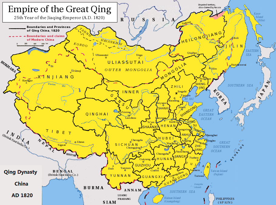
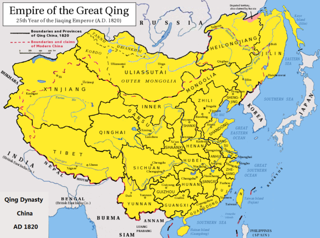
English: Map of the Qing Dynasty China in 1820. (Includes provincial boundaries and the boundaries of modern China for reference.) Adapted from http://en.wikipedia.org/wiki/Image:ROC_PRC_comparison_eng.jpg and information complied from other sources such as http://baike.baidu.com/view/5405.htm , http://map.huhai.net/58-59.jpg and http://www.sina7.com/jdwh/UploadFiles_6109/200709/20070918093610860.jpg 中文(简体):大清嘉庆二十五年疆域图。 中文(繁體):大清嘉慶廿五年疆域圖。 日本語: 大清の嘉慶25年の疆域の図。 Tiếng Việt: Đại Thanh bản đồ (1820). |
| 日期 | (UTC) |
| 来源 |
|
| 作者 |
|
| 这是一张修改过的图片,这意味着它已在原版本的基础上通过软件进行了编辑,改动内容:border islands。其原始版本为:Qing Dynasty 1820.png。
|
我,本作品著作权人,特此采用以下许可协议发表本作品:
本文件采用知识共享署名-相同方式共享 3.0 未本地化版本许可协议授权。
- 您可以自由地:
- 共享 – 复制、发行并传播本作品
- 修改 – 改编作品
- 惟须遵守下列条件:
- 署名 – 您必须对作品进行署名,提供授权条款的链接,并说明是否对原始内容进行了更改。您可以用任何合理的方式来署名,但不得以任何方式表明许可人认可您或您的使用。
- 相同方式共享 – 如果您再混合、转换或者基于本作品进行创作,您必须以与原先许可协议相同或相兼容的许可协议分发您贡献的作品。

|
已授权您依据自由软件基金会发行的无固定段落及封面封底文字(Invariant Sections, Front-Cover Texts, and Back-Cover Texts)的GNU自由文件许可协议1.2版或任意后续版本的条款,复制、传播和/或修改本文件。该协议的副本请见“GNU Free Documentation License”。 |
您可以选择您需要的许可协议。
原始上传日志
This image is a derivative work of the following images:
- File:Qing_Dynasty_1820.png licensed with Cc-by-sa-3.0, GFDL
- 2010-06-22T03:48:22Z Benlisquare 910x675 (363965 Bytes) Revert - redraw the map yourself. MS Paint overlaying of a corner is an eyesore. Illogical to have the title repeated twice.
- 2010-06-21T21:46:33Z Hisacw 910x675 (395648 Bytes) rv to NPOVify: the status on certain outlier islands (e.g. Sakhalin) is not explicitly defined, c.f. the map [http://go-passport.grolier.com/map?id=mh00032&pid=go]
- 2010-06-20T05:59:11Z Benlisquare 910x675 (363965 Bytes) Reverted to version as of 19:58, 27 September 2008
- 2010-06-20T05:58:44Z Benlisquare 910x675 (363965 Bytes) possible POV vandal
- 2010-06-19T05:34:53Z Hisacw 910x675 (395648 Bytes) small adj from original
- 2008-10-15T02:32:20Z Pryaltonian 910x675 (363965 Bytes) Reverted to version as of 19:58, 27 September 2008
- 2008-10-15T02:29:27Z Pryaltonian 910x675 (400039 Bytes) [[Category:China]] [[Category:Taiwan]] [[Category:Tibet]] [[Category:Mongolia]]
- 2008-09-27T19:58:02Z Pryaltonian 910x675 (363965 Bytes) {{Information |Description={{en|1=Map of the Qing Dynasty at its greatest extent. Includes provincial boundaries and the boundaries of modern China for reference.}} |Source=Own work by uploader |Author=[[User:Pryaltonian|Pry
Uploaded with derivativeFX
文件历史
点击某个日期/时间查看对应时刻的文件。
| 日期/时间 | 缩略图 | 大小 | 用户 | 备注 | |
|---|---|---|---|---|---|
| 当前 | 2020年2月23日 (日) 06:02 | | 910 × 675(327 KB) | Morrisonjohn022 | Reverted to version as of 17:00, 23 July 2011 (UTC) While the indigenous peoples of Sakhalin was not Han Chinese, Sakhalin was claimed by the Qing Empire and it was recognized as such by other countries (until the 1858 Treaty of Aigun and 1860 Treaty of Peking gave the island to Russia). See p. 11 of "Restless Empire: China and the World Since 1750" by Odd Arne Westad, p. 200 of "Ethnic Groups of North, East, and Central Asia: An Encyclopedia" by James B. Minahan, and p. 2 of "Across Forest,... |
| 2019年10月26日 (六) 12:35 |  | 910 × 675(386 KB) | Artanisen | Reverted to version as of 22:40, 24 October 2010 (UTC) Sakhalin was not Chinese. It was first occupied by the indigenous Ainu people and later it became half Japanese (Karafuto) and Russian (Sakhalin) then it became wholly part of the Russian Federation after WW2 | |
| 2011年7月23日 (六) 17:00 |  | 910 × 675(327 KB) | Shibo77 | .. | |
| 2010年10月24日 (日) 22:40 |  | 910 × 675(386 KB) | Wengier | minor | |
| 2010年10月24日 (日) 22:35 |  | 910 × 675(386 KB) | Wengier | {{Information |Description={{en|1=Map of the Qing Dynasty China in 1820. (Includes provincial boundaries and the boundaries of modern China for reference.)<br/>Adapted from http://en.wikipedia.org/wiki/Image:ROC_PRC_comparison_eng.jpg and information comp |
文件用途
以下页面使用本文件:
全域文件用途
以下其他wiki使用此文件:
- bcl.wikipedia.org上的用途
- be.wikipedia.org上的用途
- bn.wikipedia.org上的用途
- en.wikipedia.org上的用途
- hi.wikipedia.org上的用途
- ml.wikipedia.org上的用途
- pl.wikipedia.org上的用途
- pnb.wikipedia.org上的用途
- ru.wikipedia.org上的用途
- tl.wikipedia.org上的用途
- ur.wikipedia.org上的用途