
File:St helens map showing 1980 eruption deposits.png
此为最大尺寸。
St_helens_map_showing_1980_eruption_deposits.png (702 × 527像素,文件大小:18 KB,MIME类型:image/png)
摘要
| 描述 | |
| 来源 | USGS |
| 作者 | USGS |

|
此geology图片可使用矢量图形重新创建为SVG文件。这具有很多好处;更多信息请参见共享资源:待清理媒体。如果存在此图片的SVG格式,请将其上传,然后将此模板替换为
{{vector version available|新图片名称}}。
建议您将SVG命名为“St helens map showing 1980 eruption deposits.svg”,这样在使用Vector version available(或Vva)模板时就不需要填写新图片名称参数。 |
许可协议
|
|
原始上传日志
原始描述頁面位於這裡。下列使用者名稱均來自en.wikipedia。
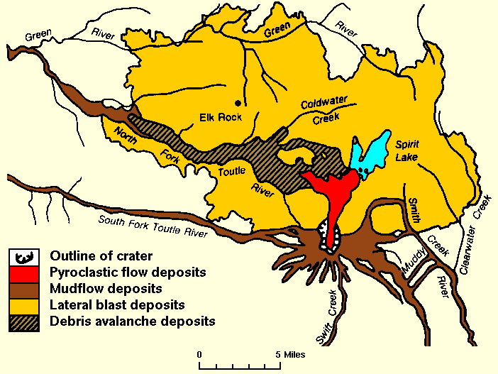
- 2007-12-27 01:18 Peteforsyth 702×527× (17938 bytes) replacing jpeg version, and cropping out extraneous text. Map of the area around Mount St. Helens which were affected by the May 18, 1980 eruption. North is to the top. [[USGS]] image from [http://vulcan.wr.usgs.gov/Volcanoes/MSH/SlideSet/ljt_slideset_
文件历史
点击某个日期/时间查看对应时刻的文件。
| 日期/时间 | 缩略图 | 大小 | 用户 | 备注 | |
|---|---|---|---|---|---|
| 当前 | 2011年5月24日 (二) 18:18 | | 702 × 527(18 KB) | File Upload Bot (Magnus Manske) | {{BotMoveToCommons|en.wikipedia|year={{subst:CURRENTYEAR}}|month={{subst:CURRENTMONTHNAME}}|day={{subst:CURRENTDAY}}}} {{Information |Description={{en|replacing jpeg version, and cropping out extraneous text. Map of the area around Mount St. Helens whic |
文件用途
全域文件用途
以下其他wiki使用此文件:
- bg.wikipedia.org上的用途
- cs.wikipedia.org上的用途
- el.wikipedia.org上的用途
- en.wikipedia.org上的用途
- fa.wikipedia.org上的用途
- id.wikipedia.org上的用途
- km.wikipedia.org上的用途
- mk.wikipedia.org上的用途
- ms.wikipedia.org上的用途
- ne.wikipedia.org上的用途
- nl.wikipedia.org上的用途
- pt.wikipedia.org上的用途
- simple.wikipedia.org上的用途
- sr.wikipedia.org上的用途
- te.wikipedia.org上的用途
- th.wikipedia.org上的用途
- tr.wikipedia.org上的用途
- uk.wikipedia.org上的用途
- uz.wikipedia.org上的用途
- vi.wikipedia.org上的用途