
File:Hurricane Irene Aug 15 2005.jpg

原始檔案 (7,200 × 5,600 像素,檔案大小:5.6 MB,MIME 類型:image/jpeg)
摘要
| 描述 |
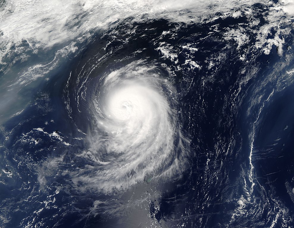
Irene was a Category 1 storm with sustained winds of 150 kilometers per hour (90 miles per hour) and stronger gusts when the Moderate Resolution Imaging Spectroradiometer (MODIS) on NASA’s Aqua satellite captured this image on August 15, 2005. The third hurricane of the 2005 Atlantic season, Irene is not expected to threaten land. While Hurricane Irene may not affect the United States or Canada, it is having an effect on haze over the Atlantic Ocean. Hot, humid weather in the Mid-Atlantic states has allowed pollution to build up. As the haze flows out to sea, it is encountering Hurricane Irene, which is steering the haze in a wide circle around its northern edge. The large image provided above is at MODIS maximum resolution of 250 meters per pixel. The image is available in additional resolutions from the MODIS Rapid Response Team. |
|||||
| 日期 | ||||||
| 來源 | http://earthobservatory.nasa.gov/NaturalHazards/natural_hazards_v2.php3?img_id=13051 | |||||
| 作者 | NASA image courtesy Jeff Schmaltz, MODIS Land Rapid Response Team at NASA GSFC | |||||
| 授權許可 (重用此檔案) |
|

檔案歷史
點選日期/時間以檢視該時間的檔案版本。
| 日期/時間 | 縮圖 | 尺寸 | 用戶 | 備註 | |
|---|---|---|---|---|---|
| 目前 | 2005年8月17日 (三) 02:35 | | 7,200 × 5,600(5.6 MB) | Tom | {{PD-USGov-NASA}} http://earthobservatory.nasa.gov/NaturalHazards/Archive/Aug2005/Irene_AMO_2005227_lrg.jpg Hurricane Irene was a Category 1 storm with sustained winds of 150 kilometers per hour (90 miles per hour) and stronger gus |
檔案用途
下列20個頁面有用到此檔案:
- 2005年大西洋飓风季时间轴
- 2005年大西洋飓风季的风暴
- Talk:飓风艾琳 (2005年)
- User:Bluedecklibrary/2005年大西洋飓风季时间轴
- Wikipedia:优良条目/2005年飓风艾琳
- Wikipedia:优良条目/2014年7月
- Wikipedia:优良条目/2014年7月3日
- Wikipedia:典范条目/2005年飓风艾琳
- Wikipedia:典范条目/2014年11月
- Wikipedia:典范条目/2014年11月19日
- Wikipedia:典范条目/2017年2月
- Wikipedia:典范条目/2017年2月13日
- Wikipedia:典范条目/2019年6月
- Wikipedia:典范条目/2019年6月26日
- Wikipedia:典范条目/2023年5月
- Wikipedia:典范条目/2023年5月24日
- Portal:美国/特色条目/219
- Portal:美國/優良條目
- Portal:美國/優良條目/21
- Portal:美國/特色條目
全域檔案使用狀況
以下其他 wiki 使用了這個檔案:
- ca.wikipedia.org 的使用狀況
- de.wikipedia.org 的使用狀況
- en.wikipedia.org 的使用狀況
- eo.wikipedia.org 的使用狀況
- es.wikipedia.org 的使用狀況
- eu.wikipedia.org 的使用狀況
- fr.wikipedia.org 的使用狀況
- pt.wikipedia.org 的使用狀況
- simple.wikipedia.org 的使用狀況
- tl.wikipedia.org 的使用狀況
- www.wikidata.org 的使用狀況